
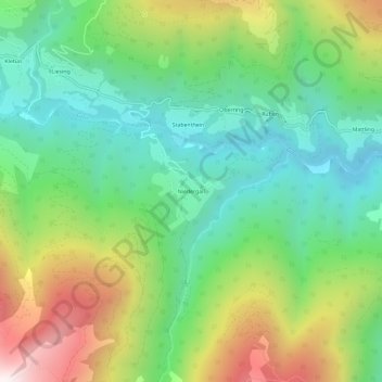
Niedergail topographic map
Interactive map
Click on the map to display elevation.
About this map
Name: Niedergail topographic map, elevation, terrain.
Average elevation: 1,281 m
Minimum elevation: 867 m
Maximum elevation: 2,046 m
Other topographic maps
Click on a map to view its topography, its elevation and its terrain.
Tscheltsch
Österreich > Kärnten > Bezirk Hermagor > Lesachtal
Tscheltsch, Lesachtal, Bezirk Hermagor, Kärnten, 9653, Österreich
Average elevation: 1,322 m
Maria Luggau
Österreich > Kärnten > Bezirk Hermagor > Lesachtal
Maria Luggau, Lesachtal, Bezirk Hermagor, Kärnten, 9655, Österreich
Average elevation: 1,449 m
Hohe Warte
Österreich > Kärnten > Bezirk Hermagor > Lesachtal
Hohe Warte, Lesachtal, Bezirk Hermagor, Kärnten, Österreich
Average elevation: 2,124 m