
Make a donation
Gear up for your next adventure:
As an Amazon Associate, this site earns from qualifying purchases at no extra cost to you.
Granges de la Pia topographic map
Click on the map to display elevation.
Make a donation
Gear up for your next adventure:
As an Amazon Associate, this site earns from qualifying purchases at no extra cost to you.
About this map
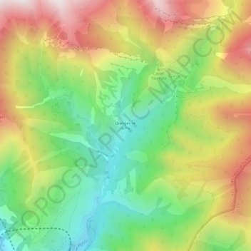
Name: Granges de la Pia topographic map, elevation, terrain.
Average elevation: 1,313 m
Minimum elevation: 829 m
Maximum elevation: 1,918 m
Make a donation
Gear up for your next adventure:
As an Amazon Associate, this site earns from qualifying purchases at no extra cost to you.
Other topographic maps
Click on a map to view its topography, its elevation and its terrain.
Fort Tabourde
France > Provence-Alpes-Côte d'Azur > Alpes-Maritimes > Tende
Average elevation: 1,673 m
Vallée des Merveilles
France > Provence-Alpes-Côte d'Azur > Alpes-Maritimes > Tende
Average elevation: 2,416 m
Lac de l'Agnel
France > Provence-Alpes-Côte d'Azur > Alpes-Maritimes > Tende
Average elevation: 2,510 m
Make a donation
Gear up for your next adventure:
As an Amazon Associate, this site earns from qualifying purchases at no extra cost to you.
Refuge de Fontanalba
France > Provence-Alpes-Côte d'Azur > Alpes-Maritimes > Tende
Average elevation: 2,122 m