
Town of Rhinebeck topographic map
Interactive map
Click on the map to display elevation.
About this map
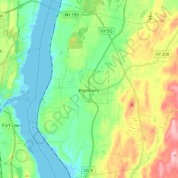
Name: Town of Rhinebeck topographic map, elevation, terrain.
Location: Town of Rhinebeck, Dutchess County, New York, United States (41.87294 -73.96384 41.98170 -73.82154)
Average elevation: 66 m
Minimum elevation: -9 m
Maximum elevation: 209 m
Other topographic maps
Click on a map to view its topography, its elevation and its terrain.
Town of North East
United States > New York > Dutchess County
Town of North East, Dutchess County, New York, 12546, United States
Average elevation: 267 m
Tory Hill
United States > New York > Dutchess County > Town of Milan
Tory Hill, Town of Milan, Dutchess County, New York, United States
Average elevation: 167 m
Rhinebeck
United States > New York > Dutchess County > Rhinebeck
Rhinebeck, Town of Rhinebeck, Dutchess County, New York, United States
Average elevation: 55 m
City of Poughkeepsie
United States > New York > Dutchess County
City of Poughkeepsie, Dutchess County, New York, 12601, United States
Average elevation: 49 m