
Make a donation
Gear up for your next adventure:
As an Amazon Associate, this site earns from qualifying purchases at no extra cost to you.
Sivaganga topographic map
Click on the map to display elevation.
Make a donation
Gear up for your next adventure:
As an Amazon Associate, this site earns from qualifying purchases at no extra cost to you.
Sivaganga
Sivaganga has an average elevation of 102 metres (334 feet). The town has a tropical wet and dry climate. The maximum temperature during summer is 37 °C or 98.6 °F and during winter it is 28 °C or 82.4 °F. The minimum temperature varies from 23.9 to 27.8 °C (75.0 to 82.0 °F). The seasonal climate conditions are moderate and the weather is uniformly salubrious. The town gets the majority of its rainfall during the north east monsoon period. The average annual rainfall is 931 millimetres or 36.65 inches.
Make a donation
Gear up for your next adventure:
As an Amazon Associate, this site earns from qualifying purchases at no extra cost to you.
About this map
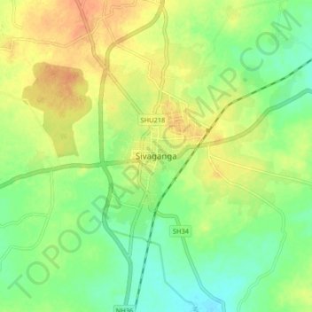
Name: Sivaganga topographic map, elevation, terrain.
Location: Sivaganga, Sivagangai, Tamil Nadu, 623560, India (9.80869 78.44705 9.88869 78.52705)
Average elevation: 98 m
Minimum elevation: 80 m
Maximum elevation: 115 m
Make a donation
Gear up for your next adventure:
As an Amazon Associate, this site earns from qualifying purchases at no extra cost to you.