
Thank you for supporting this site ❤️
Make a donation
Make a donation
Gear up for your next adventure:
As an Amazon Associate, this site earns from qualifying purchases at no extra cost to you.
Mittelscheid topographic map
Click on the map to display elevation.
Thank you for supporting this site ❤️
Make a donation
Make a donation
Gear up for your next adventure:
As an Amazon Associate, this site earns from qualifying purchases at no extra cost to you.
Mittelscheid
Das Dorf liegt in einer Höhe von 180 m ü. NHN auf den Hängen des Westerwaldes in der Gemarkung Süchterscheid. Nachbarorte sind Niederscheid im Nordosten und Oberscheid im Südwesten.
Thank you for supporting this site ❤️
Make a donation
Make a donation
Gear up for your next adventure:
As an Amazon Associate, this site earns from qualifying purchases at no extra cost to you.
About this map
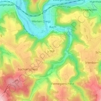
Name: Mittelscheid topographic map, elevation, terrain.
Average elevation: 159 m
Minimum elevation: 72 m
Maximum elevation: 255 m
Thank you for supporting this site ❤️
Make a donation
Make a donation
Gear up for your next adventure:
As an Amazon Associate, this site earns from qualifying purchases at no extra cost to you.