
Make a donation
Gear up for your next adventure:
As an Amazon Associate, this site earns from qualifying purchases at no extra cost to you.
Tizi Ouzou topographic map
Click on the map to display elevation.
Make a donation
Gear up for your next adventure:
As an Amazon Associate, this site earns from qualifying purchases at no extra cost to you.
Tizi Ouzou
This city is located in the heart of Kabylie. It is 102.36 square kilometres (39.52 sq mi) in area. Tizi Ouzou is located in the valley of Assif N Sébaou. It is surrounded by mountains. The city is at an altitude of 200 metres (660 ft). It is bounded on the north by Mount Belloua which rises to 850 metres (2,790 ft) above sea level. A portion of the old city of Tizi Ouzou (known as the High City) backed the east slopes of the mountain. At the top of the mountain Belloua lies the village of Redjaouna. The latter is attached to the town of Tizi Ouzou.
Make a donation
Gear up for your next adventure:
As an Amazon Associate, this site earns from qualifying purchases at no extra cost to you.
About this map
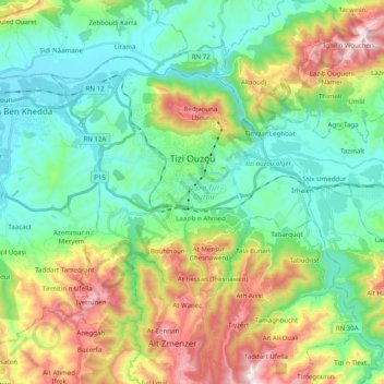
Name: Tizi Ouzou topographic map, elevation, terrain.
Location: Tizi Ouzou, Tizi Ouzou District, Tizi Ouzou, Algeria (36.64371 3.97618 36.75585 4.17462)
Average elevation: 266 m
Minimum elevation: 31 m
Maximum elevation: 789 m
Make a donation
Gear up for your next adventure:
As an Amazon Associate, this site earns from qualifying purchases at no extra cost to you.
Other topographic maps
Click on a map to view its topography, its elevation and its terrain.
Azaghar (chamlal)
Algeria > Tizi Ouzou > Tizi Ouzou District > Tizi Ouzou > Ioualayen
Average elevation: 103 m