Geolocate

Parrita topographic map

Click on the map to display elevation.

About this map

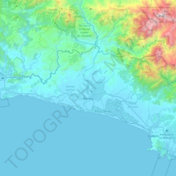
Name: Parrita topographic map, elevation, terrain.

Location: Parrita, Puntarenas Province, 60901, Costa Rica (9.44500 -84.56258 9.64942 -84.13046)

Average elevation: 277 m

Minimum elevation: -1 m

Maximum elevation: 2,477 m

Gear up for your next adventure:

📷Outdoor Action Camera - Capture high-elevation views and rugged adventures
🔥Emergency Fire Starter - Reliable ignition source for all weather conditions
🔦LED Headtorch - Bright and durable light for night activities
🧥Waterproof Jacket - Lightweight rain jackets for hiking and outdoor activities
🥾Hiking Shoes - Durable and comfortable shoes for trail hiking

As an Amazon Associate, this site earns from qualifying purchases at no extra cost to you.