
Make a donation
Gear up for your next adventure:
As an Amazon Associate, this site earns from qualifying purchases at no extra cost to you.
La Malène topographic map
Click on the map to display elevation.
Make a donation
Gear up for your next adventure:
As an Amazon Associate, this site earns from qualifying purchases at no extra cost to you.
About this map
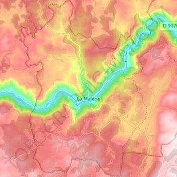
Name: La Malène topographic map, elevation, terrain.
Average elevation: 841 m
Minimum elevation: 435 m
Maximum elevation: 1,092 m
Make a donation
Gear up for your next adventure:
As an Amazon Associate, this site earns from qualifying purchases at no extra cost to you.
Other topographic maps
Click on a map to view its topography, its elevation and its terrain.
Saint-Chély-du-Tarn
Frankrijk > Occitanië > Lozère > Gorges du Tarn Causses > Sainte-Enimie
Average elevation: 820 m
Col de Finiels
Frankrijk > Occitanië > Lozère > Mont Lozère et Goulet
De Col de Finiels is een bergpas op de Mont Lozère in het Franse departement Lozère. De pasweg, de D20, kruist de Mont Lozère, de hoogste berg van de Cevennen, van zuid naar noord. De pashoogte (1541 m) zelf ligt tussen de Sommet de Finiels (1699 m) in het westen en een andere top van de Mont Lozère met…
Average elevation: 1,537 m
Make a donation
Gear up for your next adventure:
As an Amazon Associate, this site earns from qualifying purchases at no extra cost to you.