
Make a donation
Gear up for your next adventure:
As an Amazon Associate, this site earns from qualifying purchases at no extra cost to you.
Sunland Park topographic map
Click on the map to display elevation.
Make a donation
Gear up for your next adventure:
As an Amazon Associate, this site earns from qualifying purchases at no extra cost to you.
About this map
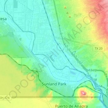
Name: Sunland Park topographic map, elevation, terrain.
Average elevation: 1,197 m
Minimum elevation: 1,128 m
Maximum elevation: 1,406 m
Make a donation
Gear up for your next adventure:
As an Amazon Associate, this site earns from qualifying purchases at no extra cost to you.
Other topographic maps
Click on a map to view its topography, its elevation and its terrain.
White Sands Missile Range
United States > New Mexico > Doña Ana County > White Sands
Average elevation: 1,306 m
White Sands Missile Range
United States > New Mexico > Doña Ana County > White Sands
Average elevation: 1,306 m
Make a donation
Gear up for your next adventure:
As an Amazon Associate, this site earns from qualifying purchases at no extra cost to you.