Geolocate

Pangarchulla topographic map

Click on the map to display elevation.

About this map

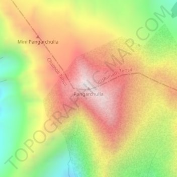
Name: Pangarchulla topographic map, elevation, terrain.

Location: Pangarchulla, Joshimath Tehsil, Chamoli, Uttarakhand, 246483, India (30.42362 79.59209 30.42372 79.59219)

Average elevation: 4,061 m

Minimum elevation: 3,494 m

Maximum elevation: 4,570 m

Other topographic maps

Click on a map to view its topography, its elevation and its terrain.

Mana

India > Uttarakhand > Joshimath Tehsil

Average elevation: 4,959 m

Saraswati

India > Uttarakhand > Joshimath Tehsil > Mana

Average elevation: 5,393 m

Hemkund

India > Uttarakhand > Joshimath Tehsil

Average elevation: 4,367 m

Gear up for your next adventure:

🌬️Windproof Camp Stove - Efficient cooking even on exposed mountain peaks
🧥Softshell Hiking Jacket - The perfect balance of wind protection and breathability
❄️Traction Ice Cleats - Slip-on spikes for icy trails and winter hiking
🧥Packable Rain Jacket - Breathable waterproof layer for unpredictable weather
🧥Ultralight Puffy Jacket - Maximum warmth that packs down to the size of an orange

As an Amazon Associate, this site earns from qualifying purchases at no extra cost to you.