Geolocate

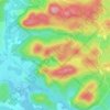
Mont Alta topographic map

Click on the map to display elevation.

About this map

Name: Mont Alta topographic map, elevation, terrain.

Location: Mont Alta, Val-David, Les Laurentides, Laurentides, Québec, J0T 2N0, Canada (46.03505 -74.23841 46.03515 -74.23831)

Average elevation: 382 m

Minimum elevation: 319 m

Maximum elevation: 485 m

Other topographic maps

Click on a map to view its topography, its elevation and its terrain.
Lac Campeau

Canada > Québec > Les Laurentides > Val-David

Average elevation: 381 m

Lac Paquin

Canada > Québec > Les Laurentides > Val-David

Average elevation: 411 m

Gear up for your next adventure:

🧼Biodegradable Camp Soap - Environmentally friendly cleaning for gear and body
💧Collapsible Water Bottle - Space-saving water bottle for outdoor activities
⛺Camping Tent - Weather-resistant tents suitable for 2 to 6 people
🥾Hiking Shoes - Durable and comfortable shoes for trail hiking
👟Trail Running Shoes - Agile footwear for fast-paced topographic exploration

As an Amazon Associate, this site earns from qualifying purchases at no extra cost to you.