
Sardinia topographic map
Click on the map to display elevation.
Sardinia
The climate of the island is variable from area to area, due to several factors including the extension in latitude and the elevation. It can be classified in two different macrobioclimates (Mediterranean pluviseasonal oceanic and Temperate oceanic), one macrobioclimatic variant, called Submediterranean, and four classes of continentality (from weak semihyperoceanic to weak semicontinental), eight thermotypic horizons (from lower thermomediterranean to upper supratemperate) and seven ombrotypic horizons (from lower dry to lower hyperhumid), resulting in a combination of 43 different isobioclimates.
About this map
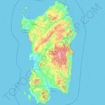
Name: Sardinia topographic map, elevation, terrain.
Location: Sardinia, Austis, Nuoro, Sardinia, 08030, Italy (38.86401 8.13084 41.25908 9.82885)
Average elevation: 115 m
Minimum elevation: -2 m
Maximum elevation: 1,813 m