Geolocate

Camerana topographic map

Click on the map to display elevation.

About this map

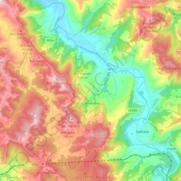
Name: Camerana topographic map, elevation, terrain.

Location: Camerana, Cuneo, Piedmont, 12072, Italy (44.39482 8.10150 44.46263 8.16617)

Average elevation: 565 m

Minimum elevation: 350 m

Maximum elevation: 794 m

Other topographic maps

Click on a map to view its topography, its elevation and its terrain.

Bertolini

Italy > Piedmont > Cuneo > Crissolo

Average elevation: 1,686 m

Montescotto

Italy > Piedmont > Cuneo > Barge

Average elevation: 643 m

Monastero

Italy > Piedmont > Cuneo > Mondovì

Average elevation: 448 m

Pievetta

Italy > Piedmont > Cuneo

Average elevation: 735 m

Pianche

Italy > Piedmont > Cuneo

Average elevation: 1,496 m

San Bernolfo

Italy > Piedmont > Cuneo > Vinadio

Average elevation: 2,036 m

Gear up for your next adventure:

🧢Outdoor Visor - Breathable visor for sunny hikes
🧦Merino Wool Socks - Moisture-wicking comfort for long-distance hiking
🛶Canoe Life Vest - Safety vest for water sports
👖Convertible Hiking Pants - Zip-off legs to adapt to changing weather conditions
🗺️Topographic Maps - Detailed maps to explore trails, mountains, and wilderness areas

As an Amazon Associate, this site earns from qualifying purchases at no extra cost to you.