Geolocate

Monastero topographic map

Click on the map to display elevation.

About this map

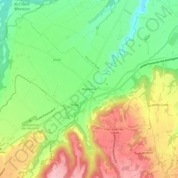
Name: Monastero topographic map, elevation, terrain.

Location: Monastero, Mondovì, Cuneo, Piedmont, 12047, Italy (44.37866 7.72498 44.41866 7.76498)

Average elevation: 448 m

Minimum elevation: 370 m

Maximum elevation: 539 m

Gear up for your next adventure:

🧭GPS Tracker - Track your location in remote areas safely
🧥Packable Rain Jacket - Breathable waterproof layer for unpredictable weather
🧊Insulated Water Bottle - Keeps drinks cold in summer and prevents freezing in winter
🎒Backpack Rain Cover - External shield to keep your entire pack dry
🥾Trail Hiking Boots - Supportive boots for rough trails

As an Amazon Associate, this site earns from qualifying purchases at no extra cost to you.