
Make a donation
Gear up for your next adventure:
As an Amazon Associate, this site earns from qualifying purchases at no extra cost to you.
Māhoenui topographic map
Click on the map to display elevation.
Make a donation
Gear up for your next adventure:
As an Amazon Associate, this site earns from qualifying purchases at no extra cost to you.
Māhoenui
Māhoenui is located in the King Country approx 50 kilometres (31 mi) inland from the west coast of the North Island, the topography is hilly to mountainous, with small alluvial areas near the streams and river.
Make a donation
Gear up for your next adventure:
As an Amazon Associate, this site earns from qualifying purchases at no extra cost to you.
About this map
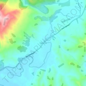
Name: Māhoenui topographic map, elevation, terrain.
Location: Māhoenui, Waitomo District, Waikato, New Zealand (-38.59855 174.82063 -38.55855 174.86063)
Average elevation: 113 m
Minimum elevation: 49 m
Maximum elevation: 358 m
Make a donation
Gear up for your next adventure:
As an Amazon Associate, this site earns from qualifying purchases at no extra cost to you.