
Make a donation
Gear up for your next adventure:
As an Amazon Associate, this site earns from qualifying purchases at no extra cost to you.
Wilder Kaiser topographic map
Click on the map to display elevation.
Make a donation
Gear up for your next adventure:
As an Amazon Associate, this site earns from qualifying purchases at no extra cost to you.
Wilder Kaiser
The Kaiser Mountains are divided into the Wilder Kaiser or Wild Kaiser chain of mountains, formed predominantly of bare limestone rock, and the Zahmer Kaiser ("Tame Kaiser"), whose southern side is mainly covered by mountain pine. These two mountain ridges are linked by the 1,580-metre-high Stripsenjoch pass, but are separated in the west by the valley of Kaisertal and in the east by the Kaiserbach valley. In total the Kaiser extends for about 20 km (12 mi) in an east-west direction and about 14 km (8.7 mi) from north to south, giving a total area of some 280 square kilometres (110 sq mi). The Zahmer Kaiser only just breaks through the 2,000 metre barrier (in the Vordere Kesselschneid). The highest elevation in the Wilder Kaiser is the Ellmauer Halt in the borough of Kufstein at 2,344 metres (7,690 ft). There are around forty other summits, including many well-known climbing peaks such as the Karlspitzen, Totenkirchl, Fleischbank, Predigtstuhl, Goinger Halt, Ackerlspitze and Maukspitze.
Make a donation
Gear up for your next adventure:
As an Amazon Associate, this site earns from qualifying purchases at no extra cost to you.
About this map
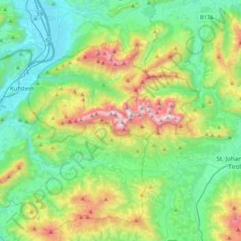
Name: Wilder Kaiser topographic map, elevation, terrain.
Location: Wilder Kaiser, Bezirk Kufstein, Austria (47.51260 12.15157 47.60053 12.44526)
Average elevation: 976 m
Minimum elevation: 461 m
Maximum elevation: 2,300 m
Make a donation
Gear up for your next adventure:
As an Amazon Associate, this site earns from qualifying purchases at no extra cost to you.
Other topographic maps
Click on a map to view its topography, its elevation and its terrain.
Make a donation
Gear up for your next adventure:
As an Amazon Associate, this site earns from qualifying purchases at no extra cost to you.
Königsleiten
Austria > Salzburg > Bezirk Zell am See > Gemeinde Wald im Pinzgau > Königsleiten
Average elevation: 1,703 m