
Thank you for supporting this site ❤️
Make a donation
Make a donation
Gear up for your next adventure:
As an Amazon Associate, this site earns from qualifying purchases at no extra cost to you.
Agés topographic map
Click on the map to display elevation.
Thank you for supporting this site ❤️
Make a donation
Make a donation
Gear up for your next adventure:
As an Amazon Associate, this site earns from qualifying purchases at no extra cost to you.
About this map
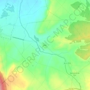
Name: Agés topographic map, elevation, terrain.
Location: Agés, Arlanzón, Burgos, Castille-et-León, Espagne (42.34992 -3.49924 42.38992 -3.45924)
Average elevation: 974 m
Minimum elevation: 928 m
Maximum elevation: 1,061 m
Thank you for supporting this site ❤️
Make a donation
Make a donation
Gear up for your next adventure:
As an Amazon Associate, this site earns from qualifying purchases at no extra cost to you.