
Make a donation
Gear up for your next adventure:
As an Amazon Associate, this site earns from qualifying purchases at no extra cost to you.
La Longée topographic map
Click on the map to display elevation.
Make a donation
Gear up for your next adventure:
As an Amazon Associate, this site earns from qualifying purchases at no extra cost to you.
About this map
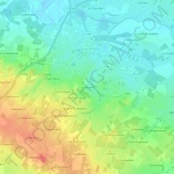
Name: La Longée topographic map, elevation, terrain.
Average elevation: 21 m
Minimum elevation: -1 m
Maximum elevation: 54 m
Make a donation
Gear up for your next adventure:
As an Amazon Associate, this site earns from qualifying purchases at no extra cost to you.
Other topographic maps
Click on a map to view its topography, its elevation and its terrain.
44310
France > Pays de la Loire > Loire-Atlantique > Saint-Philbert-de-Grand-Lieu > La Guinèvre
Average elevation: 5 m
Lac de Grand-Lieu
France > Pays de la Loire > Loire-Atlantique > Saint-Philbert-de-Grand-Lieu
Le sol du site s'est formé il y a 50 millions d'années, tandis que la configuration topographique s'est formée il y a deux millions d'années. Le paysage observable au XXI siècle prend forme au néolithique.
Average elevation: 2 m