Geolocate

Raglan topographic map

Click on the map to display elevation.

About this map

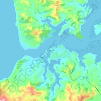
Name: Raglan topographic map, elevation, terrain.

Location: Raglan, Waikato District, Waikato, 3225, New Zealand (-37.84035 174.83443 -37.76035 174.91443)

Average elevation: 41 m

Minimum elevation: -1 m

Maximum elevation: 184 m

Other topographic maps

Click on a map to view its topography, its elevation and its terrain.

Hūnua Ranges

New Zealand > Waikato > Waikato District

Average elevation: 176 m

Lake Kimihia

New Zealand > Waikato > Waikato District

Average elevation: 34 m

Lake Whangape

New Zealand > Waikato > Waikato District

Average elevation: 16 m

Lake Rotokauri

New Zealand > Waikato > Waikato District

Average elevation: 35 m

Lake E

New Zealand > Waikato > Waikato District

Average elevation: 39 m

Gear up for your next adventure:

🧭GPS Outdoor Watch - Smart watch for navigation and fitness tracking in nature
💧Hydration Pack - Hands-free hydration system for long hikes
🧭Orienteering Kit - Tools for map reading and navigation in the wild
🚲Bike Repair Kit - Essential tools for on-trail mechanical issues
🧢Beanie Hat - Keep your head warm in cold weather

As an Amazon Associate, this site earns from qualifying purchases at no extra cost to you.