Geolocate

Spröda topographic map

Click on the map to display elevation.

About this map

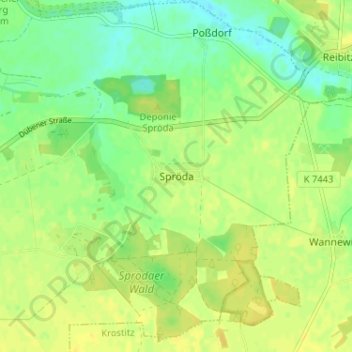
Name: Spröda topographic map, elevation, terrain.

Location: Spröda, Delitzsch, Nordsachsen, Sachsen, Deutschland (51.52251 12.40781 51.56251 12.44781)

Average elevation: 96 m

Minimum elevation: 84 m

Maximum elevation: 103 m

Gear up for your next adventure:

👟Leg Gaiters - Keep debris, mud, and snow out of your boots
🌬️Windproof Camp Stove - Efficient cooking even on exposed mountain peaks
🧦Hiking Liner Socks - Thin base layer to prevent friction and blisters
🔋Solar Power Bank - Keep your GPS and devices charged during long outdoor trips
🧢Beanie Hat - Keep your head warm in cold weather

As an Amazon Associate, this site earns from qualifying purchases at no extra cost to you.