
Thank you for supporting this site ❤️
Make a donation
Make a donation
Gear up for your next adventure:
As an Amazon Associate, this site earns from qualifying purchases at no extra cost to you.
Corigliano topographic map
Click on the map to display elevation.
Thank you for supporting this site ❤️
Make a donation
Make a donation
Gear up for your next adventure:
As an Amazon Associate, this site earns from qualifying purchases at no extra cost to you.
About this map
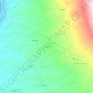
Name: Corigliano topographic map, elevation, terrain.
Location: Corigliano, Sessa Aurunca, Caserta, Campania, 81037, Italia (41.26262 13.89617 41.30262 13.93617)
Average elevation: 278 m
Minimum elevation: 7 m
Maximum elevation: 880 m
Thank you for supporting this site ❤️
Make a donation
Make a donation
Gear up for your next adventure:
As an Amazon Associate, this site earns from qualifying purchases at no extra cost to you.