Geolocate

Doso topographic map

Click on the map to display elevation.

About this map

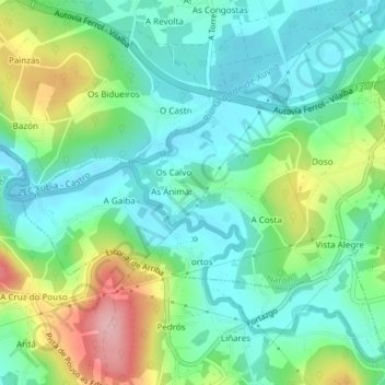
Name: Doso topographic map, elevation, terrain.

Location: Doso, Narón, Ferrol, A Coruña, Galicia, Spain (43.51102 -8.12608 43.52457 -8.08841)

Average elevation: 64 m

Minimum elevation: 14 m

Maximum elevation: 179 m

Other topographic maps

Click on a map to view its topography, its elevation and its terrain.

Nelle

Spain > Galicia > Ferrol > Narón

Average elevation: 66 m

A Vacariza

Spain > Galicia > Ferrol > Narón

Average elevation: 135 m

Vilacornelle

Spain > Galicia > Ferrol > Narón

Average elevation: 80 m

Gear up for your next adventure:

Lightweight Backpacking Tent - Compact tent for efficient hiking trips
🧢Beanie Hat - Keep your head warm in cold weather
🧤Thermal Hiking Gloves - Grip-enhanced gloves for cold-weather altitude trekking
🚲MTB Frame Bag - Carry tools and maps directly on your bicycle frame
🔦LED Headlamp - Hands-free lighting for early morning starts or late finishes

As an Amazon Associate, this site earns from qualifying purchases at no extra cost to you.