
Thank you for supporting this site ❤️
Make a donation
Make a donation
Gear up for your next adventure:
As an Amazon Associate, this site earns from qualifying purchases at no extra cost to you.
Yagra Township topographic map
Click on the map to display elevation.
Thank you for supporting this site ❤️
Make a donation
Make a donation
Gear up for your next adventure:
As an Amazon Associate, this site earns from qualifying purchases at no extra cost to you.
About this map
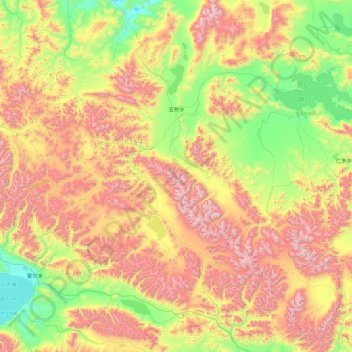
Name: Yagra Township topographic map, elevation, terrain.
Location: Yagra Township, Gegyai County, Ngari Prefecture, Tibet, China (30.50282 81.39114 31.90299 83.17602)
Average elevation: 5,199 m
Minimum elevation: 4,575 m
Maximum elevation: 6,291 m
Thank you for supporting this site ❤️
Make a donation
Make a donation
Gear up for your next adventure:
As an Amazon Associate, this site earns from qualifying purchases at no extra cost to you.