
Make a donation
Gear up for your next adventure:
As an Amazon Associate, this site earns from qualifying purchases at no extra cost to you.
Fontaine d'Isolo topographic map
Click on the map to display elevation.
Make a donation
Gear up for your next adventure:
As an Amazon Associate, this site earns from qualifying purchases at no extra cost to you.
About this map
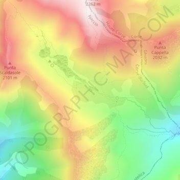
Name: Fontaine d'Isolo topographic map, elevation, terrain.
Average elevation: 1,814 m
Minimum elevation: 1,408 m
Maximum elevation: 2,208 m
Make a donation
Gear up for your next adventure:
As an Amazon Associate, this site earns from qualifying purchases at no extra cost to you.
Other topographic maps
Click on a map to view its topography, its elevation and its terrain.
Lac de Bracca
France > Corse > Corse-du-Sud > Bastelica
Situé au pied de la Punta alla Vetta (2 255 m), face au Monte Rinosu, en contrehaut du lac de Vitalaca, le lac de Bracca est un lac d'altitude de Corse-du-Sud situé à 2 085 mètres. Il est la source du fleuve Prunelli.
Average elevation: 1,959 m