
Make a donation
Gear up for your next adventure:
As an Amazon Associate, this site earns from qualifying purchases at no extra cost to you.
Pasir Putih topographic map
Click on the map to display elevation.
Make a donation
Gear up for your next adventure:
As an Amazon Associate, this site earns from qualifying purchases at no extra cost to you.
About this map
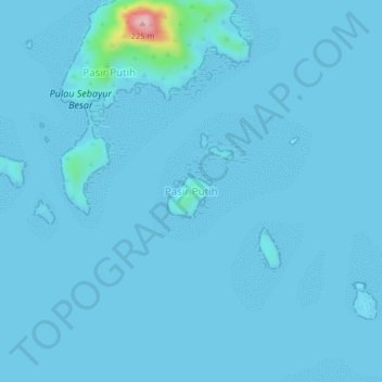
Name: Pasir Putih topographic map, elevation, terrain.
Location: Pasir Putih, Manggarai Barat, East Nusa Tenggara, Indonesia (-8.53578 119.70730 -8.49578 119.74730)
Average elevation: 7 m
Minimum elevation: 0 m
Maximum elevation: 229 m
Make a donation
Gear up for your next adventure:
As an Amazon Associate, this site earns from qualifying purchases at no extra cost to you.
Other topographic maps
Click on a map to view its topography, its elevation and its terrain.
Komodo National Park
Indonesia > East Nusa Tenggara > Manggarai Barat
The park comprises a coastal section of western Flores, the three larger islands of Komodo, Padar and Rinca, 26 smaller islands and the surrounding waters of the Sape Straights. The islands of the national park are of volcanic origin. The terrain is generally rugged, characterized by rounded hills, with…
Average elevation: 38 m
Gili Motang Island
Indonesia > East Nusa Tenggara > Manggarai Barat > Golo Mori
Average elevation: 74 m