Geolocate

Yazd topographic map

Click on the map to display elevation.

About this map

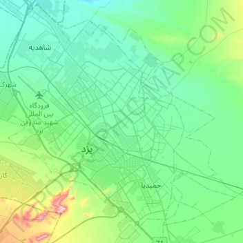
Name: Yazd topographic map, elevation, terrain.

Location: Yazd, بخش مرکزی شهرستان یزد, Yazd County, Yazd Province, Iran (31.77955 54.21684 31.97867 54.45854)

Average elevation: 1,254 m

Minimum elevation: 1,162 m

Maximum elevation: 1,640 m

Other topographic maps

Click on a map to view its topography, its elevation and its terrain.

Deh no

Iran > Yazd Province > Yazd County

Average elevation: 1,247 m

Yazd

Iran > Yazd Province > Yazd County

Average elevation: 1,290 m

Khavidak

Iran > Yazd Province > Yazd County > دهستان فهرج

Average elevation: 1,256 m

Gear up for your next adventure:

🛁Quick-Dry Microfiber Towel - Space-saving towel that dries rapidly on the move
🔦LED Flashlight - Powerful and long-lasting flashlight for camping and emergencies
🧼Biodegradable Camp Soap - Environmentally friendly cleaning for gear and body
👟Sport Hiking Sandals - Breathable footwear for water crossings and camp rest
🥾Durable Hiking Shoes - Long-lasting shoes for frequent hiking

As an Amazon Associate, this site earns from qualifying purchases at no extra cost to you.