
Make a donation
Gear up for your next adventure:
As an Amazon Associate, this site earns from qualifying purchases at no extra cost to you.
Alberoni topographic map
Click on the map to display elevation.
Make a donation
Gear up for your next adventure:
As an Amazon Associate, this site earns from qualifying purchases at no extra cost to you.
Alberoni
Una pianta di Nicolò dal Cortivo del 1530 ne mostra dettagliatamente la antica topografia, in cui compaiono zone di spiagge litoranee, formazioni a dune e coltivazioni a vigneto.
Make a donation
Gear up for your next adventure:
As an Amazon Associate, this site earns from qualifying purchases at no extra cost to you.
About this map
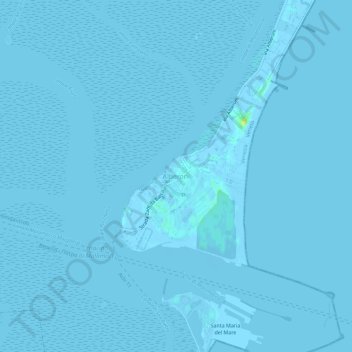
Name: Alberoni topographic map, elevation, terrain.
Average elevation: 0 m
Minimum elevation: -4 m
Maximum elevation: 17 m
Make a donation
Gear up for your next adventure:
As an Amazon Associate, this site earns from qualifying purchases at no extra cost to you.
Other topographic maps
Click on a map to view its topography, its elevation and its terrain.
Lido di Venezia
Italia > Veneto > Città Metropolitana di Venezia > Venezia > Lido
Average elevation: 1 m
via monte cervino
Italia > Veneto > Città Metropolitana di Venezia > Venezia > Favaro Veneto
Average elevation: 3 m