
Widewater topographic map
Click on the map to display elevation.
About this map
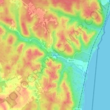
Name: Widewater topographic map, elevation, terrain.
Location: Widewater, Stafford County, Virginia, 22555, United States (38.45068 -77.35848 38.49068 -77.31848)
Average elevation: 35 m
Minimum elevation: -1 m
Maximum elevation: 64 m
Other topographic maps
Click on a map to view its topography, its elevation and its terrain.
Boswell's Corner
United States > Virginia > Stafford County > Boswell's Corner
Average elevation: 47 m
Southern Gateway
United States > Virginia > Stafford County > Southern Gateway
Average elevation: 73 m