Geolocate

Luppa topographic map

Click on the map to display elevation.

Luppa

2002 fand bereits das dritte Dreschmaschinenfest in Luppa statt. Höhepunkt des Festes ist ein Umzug mit historischer Landmaschinentechnik.

Wikipedia (CC-BY-SA 3.0)

About this map

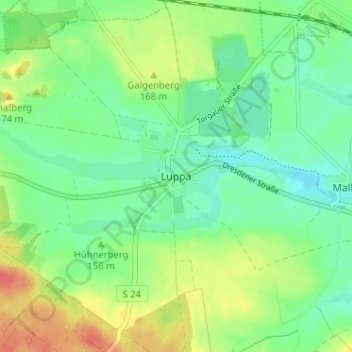
Name: Luppa topographic map, elevation, terrain.

Location: Luppa, Wermsdorf, Nordsachsen, Sachsen, 04779, Deutschland (51.31311 12.94002 51.35311 12.98002)

Average elevation: 155 m

Minimum elevation: 136 m

Maximum elevation: 187 m

Other topographic maps

Click on a map to view its topography, its elevation and its terrain.

04779

Deutschland > Sachsen > Nordsachsen > Wermsdorf

Average elevation: 184 m

Gear up for your next adventure:

🥘Camping Cookware Set - Compact nesting pots and pans for trail cooking
🧦Crew Hiking Socks - Comfortable socks for long-distance hikes
💡Compact LED Flashlight - Powerful and portable flashlight for outdoor use
🧦Hiking Liner Socks - Thin base layer to prevent friction and blisters
🪑Insulated Seat Pad - Protect your seat from cold rocks and wet logs

As an Amazon Associate, this site earns from qualifying purchases at no extra cost to you.