Geolocate

Aschheim topographic map

Click on the map to display elevation.

About this map
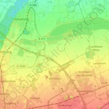
Name: Aschheim topographic map, elevation, terrain.

Location: Aschheim, Landkreis München, Bavaria, 85609, Germany (48.14429 11.67393 48.24110 11.75571)

Average elevation: 504 m

Minimum elevation: 475 m

Maximum elevation: 532 m

Other topographic maps

Click on a map to view its topography, its elevation and its terrain.
Eglfing

Germany > Bavaria > Landkreis München > Haar

Average elevation: 540 m

Martinsried

Germany > Bavaria > Landkreis München > Planegg

Average elevation: 549 m

Hofolding

Germany > Bavaria > Landkreis München

Average elevation: 609 m

Holzhausen

Germany > Bavaria > Landkreis München

Average elevation: 663 m

Deisenhofen

Germany > Bavaria > Landkreis München > Oberhaching

Average elevation: 592 m

Gear up for your next adventure:

🧢Outdoor Cap - Protective cap for sun and rain during hikes
🔥Emergency Fire Starter - Reliable ignition source for all weather conditions
🪜Heavy Duty Carabiners - Multi-use clips for securing gear to your backpack
🧥Waterproof Hiking Jacket - Protect yourself from rain and wind while hiking
🧣Merino Neck Gaiter - Protects against wind, sun, and cold at high altitudes

As an Amazon Associate, this site earns from qualifying purchases at no extra cost to you.