
Make a donation
Gear up for your next adventure:
As an Amazon Associate, this site earns from qualifying purchases at no extra cost to you.
Wigger topographic map
Click on the map to display elevation.
Make a donation
Gear up for your next adventure:
As an Amazon Associate, this site earns from qualifying purchases at no extra cost to you.
Wigger
Bei Dagmersellen nimmt der Fluss von rechts den Hürnbach auf. Dann erreicht er das weite untere Wiggertal, das mit einer Länge von zwölf Kilometern ein Gefälle von nur noch rund 70 Metern hat. In der Ebene ist die Wigger heute grösstenteils kanalisiert. Sie verläuft teilweise parallel zur Autobahn A2. Bei Brittnau überquert der Fluss die Kantonsgrenze zum Aargau, und zwischen Rothrist und Aarburg mündet er beim Wiggerspitz auf einer Höhe von 392 Metern in die Aare.
Make a donation
Gear up for your next adventure:
As an Amazon Associate, this site earns from qualifying purchases at no extra cost to you.
About this map
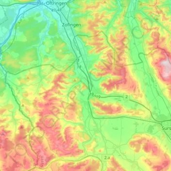
Name: Wigger topographic map, elevation, terrain.
Average elevation: 560 m
Minimum elevation: 393 m
Maximum elevation: 853 m
Make a donation
Gear up for your next adventure:
As an Amazon Associate, this site earns from qualifying purchases at no extra cost to you.