
Make a donation
Gear up for your next adventure:
As an Amazon Associate, this site earns from qualifying purchases at no extra cost to you.
Serles topographic map
Click on the map to display elevation.
Make a donation
Gear up for your next adventure:
As an Amazon Associate, this site earns from qualifying purchases at no extra cost to you.
About this map
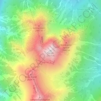
Name: Serles topographic map, elevation, terrain.
Average elevation: 2,036 m
Minimum elevation: 1,558 m
Maximum elevation: 2,685 m
Make a donation
Gear up for your next adventure:
As an Amazon Associate, this site earns from qualifying purchases at no extra cost to you.
Other topographic maps
Click on a map to view its topography, its elevation and its terrain.
Stubaital
Österreich > Tirol > Bezirk Innsbruck-Land > Fulpmes
Das Stubaital, kurz das Stubai genannt, ist das größte Seitental des Wipptals und das Haupttal der Stubaier Alpen im österreichischen Bundesland Tirol. Es erstreckt sich vom Alpenhauptkamm 35 km in nordöstlicher Richtung bis in die Nähe der Tiroler Landeshauptstadt Innsbruck. Es ist eine…
Average elevation: 1,547 m