
Azpeitia topographic map
Click on the map to display elevation.
About this map
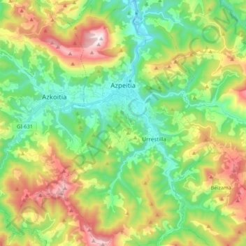
Name: Azpeitia topographic map, elevation, terrain.
Average elevation: 395 m
Minimum elevation: 55 m
Maximum elevation: 1,010 m
Other topographic maps
Click on a map to view its topography, its elevation and its terrain.
Flysch
Spain > Autonomous Community of the Basque Country > Urola-Kosta > Zumaia
Average elevation: 27 m
Floreaga
Spain > Autonomous Community of the Basque Country > Urola-Kosta > Azkoitia
Average elevation: 266 m
Makola
Spain > Autonomous Community of the Basque Country > Urola-Kosta > Azkoitia
Average elevation: 515 m