
Make a donation
Gear up for your next adventure:
As an Amazon Associate, this site earns from qualifying purchases at no extra cost to you.
Dryden topographic map
Click on the map to display elevation.
Make a donation
Gear up for your next adventure:
As an Amazon Associate, this site earns from qualifying purchases at no extra cost to you.
About this map
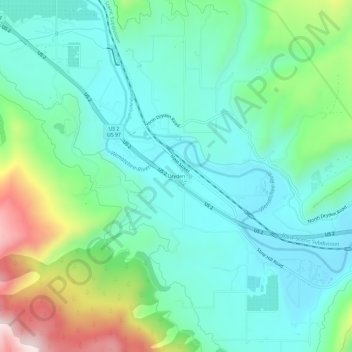
Name: Dryden topographic map, elevation, terrain.
Location: Dryden, Chelan County, Washington, 98821, United States (47.52088 -120.58224 47.56088 -120.54224)
Average elevation: 389 m
Minimum elevation: 255 m
Maximum elevation: 777 m
Make a donation
Gear up for your next adventure:
As an Amazon Associate, this site earns from qualifying purchases at no extra cost to you.
Other topographic maps
Click on a map to view its topography, its elevation and its terrain.
Lake Chelan
United States > Washington > Chelan County > Chelan
Lake Chelan (/ʃəˈlæn/ shə-LAN) is a narrow, 50.5 mi (81.3 km) long lake in Chelan County, north-central Washington state, U.S. It is an overdeepened lake and resembles a fjord, with an average width of 1.3 mi (2.1 km). Near its upper end, the lake surface lies more than 6,600 ft (2,000 m) below peaks less…
Average elevation: 1,358 m
Colchuck Lake
United States > Washington > Chelan County
Colchuck Lake has an area of approximately 87.8 acres (0.355 km2) and a maximum surface elevation of 5,570 feet above sea level, depending on the fluctuation of the depth of the lake. The lake has a tributary basin of 941 acres (3.81 km2) acres, and an average storage capacity estimated at 1,570 acre-feet.
Average elevation: 1,886 m
Wenatchee Confluence State Park
United States > Washington > Chelan County > Sunnyslope
Average elevation: 208 m
Make a donation
Gear up for your next adventure:
As an Amazon Associate, this site earns from qualifying purchases at no extra cost to you.