Geolocate

Klamath Falls topographic map

Click on the map to display elevation.

Klamath Falls

According to the United States Census Bureau, the city has a total area of 20.66 square miles (53.51 km2), of which 19.81 square miles (51.31 km2) is land and 0.85 square miles (2.20 km2) is water. The elevation is 4,094 feet (1,248 m).

Wikipedia (CC-BY-SA 3.0)

About this map

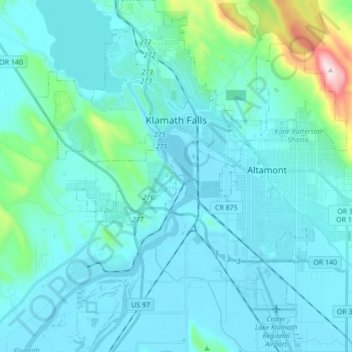
Name: Klamath Falls topographic map, elevation, terrain.

Location: Klamath Falls, Klamath County, Oregon, 97601, United States (42.14088 -121.85119 42.26834 -121.69829)

Average elevation: 1,312 m

Minimum elevation: 1,240 m

Maximum elevation: 1,887 m

Other topographic maps

Click on a map to view its topography, its elevation and its terrain.

The Cascades

United States > Oregon > Klamath County

Average elevation: 1,589 m

Gear up for your next adventure:

🧰Emergency Multi-Tool - Compact multi-tool for outdoor survival
🥾Light Hiking Boots - Lightweight and comfortable boots for day hikes
🥫Freeze-Dried Meals - Lightweight, high-calorie nutrition for multi-day treks
🥾Mountain Trail Shoes - High-traction shoes for mountain trails
🧊Insulated Water Bottle - Keeps drinks cold in summer and prevents freezing in winter

As an Amazon Associate, this site earns from qualifying purchases at no extra cost to you.