
Make a donation
Gear up for your next adventure:
As an Amazon Associate, this site earns from qualifying purchases at no extra cost to you.
Poľana topographic map
Click on the map to display elevation.
Make a donation
Gear up for your next adventure:
As an Amazon Associate, this site earns from qualifying purchases at no extra cost to you.
About this map
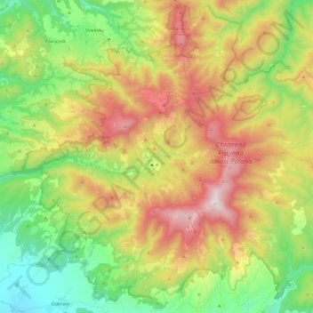
Name: Poľana topographic map, elevation, terrain.
Location: Poľana, Region of Banská Bystrica, Central Slovakia, Slovakia (48.58395 19.30733 48.73523 19.53977)
Average elevation: 823 m
Minimum elevation: 384 m
Maximum elevation: 1,443 m
Make a donation
Gear up for your next adventure:
As an Amazon Associate, this site earns from qualifying purchases at no extra cost to you.
Other topographic maps
Click on a map to view its topography, its elevation and its terrain.
Chopok
Slovakia > Region of Banská Bystrica > District of Brezno > Horná Lehota
Average elevation: 1,642 m
Kráľova hoľa
Slovakia > Region of Banská Bystrica > District of Brezno
Kráľova hoľa (Slovak pronunciation: [ˈkraːʎɔʋa ˈɦɔʎa]; German: Königsberg; Hungarian: Király-hegy, literally "King's Mountain") is the highest mountain (1,946 m) of the eastern part of the Low Tatras in central Slovakia. Four rivers rise at its foot: Čierny Váh, Hnilec, Hornád, and Hron. The…
Average elevation: 1,653 m
Make a donation
Gear up for your next adventure:
As an Amazon Associate, this site earns from qualifying purchases at no extra cost to you.
Mišúty
Slovakia > Region of Banská Bystrica > District of Banská Bystrica > Donovaly
Average elevation: 1,041 m
Chopok
Slovakia > Region of Banská Bystrica > District of Brezno > Horná Lehota
Average elevation: 1,642 m
Benda
Slovakia > Region of Banská Bystrica > District of Veľký Krtíš > Seľany
Average elevation: 317 m
Make a donation
Gear up for your next adventure:
As an Amazon Associate, this site earns from qualifying purchases at no extra cost to you.
Hrochoť
Slovakia > Region of Banská Bystrica > District of Banská Bystrica > Hrochoť > Hrochoť
Average elevation: 626 m
Stará Huta
Slovakia > Region of Banská Bystrica > District of Detva > Stará Huta > Stará Huta
Average elevation: 731 m
Chopok
Slovakia > Region of Banská Bystrica > District of Brezno > Horná Lehota
Average elevation: 1,642 m
Make a donation
Gear up for your next adventure:
As an Amazon Associate, this site earns from qualifying purchases at no extra cost to you.