Geolocate

Wenas topographic map

Click on the map to display elevation.

About this map

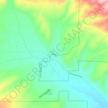
Name: Wenas topographic map, elevation, terrain.

Location: Wenas, Yakima County, Washington, United States (46.85262 -120.79396 46.89262 -120.75396)

Average elevation: 754 m

Minimum elevation: 642 m

Maximum elevation: 995 m

Other topographic maps

Click on a map to view its topography, its elevation and its terrain.

Yakima

United States > Washington > Yakima County

Average elevation: 377 m

Naches

United States > Washington > Yakima County

Average elevation: 478 m

Wenas Lake

United States > Washington > Yakima County

Average elevation: 631 m

Nile

United States > Washington > Yakima County > Nile

Average elevation: 806 m

Toppenish

United States > Washington > Yakima County

Average elevation: 232 m

Sunnyside

United States > Washington > Yakima County

Average elevation: 226 m

Nile

United States > Washington > Yakima County > Nile

Average elevation: 806 m

Yakima

United States > Washington > Yakima County

Average elevation: 377 m

Gleed

United States > Washington > Yakima County

Average elevation: 424 m

Nile

United States > Washington > Yakima County > Nile

Average elevation: 806 m

Wapato

United States > Washington > Yakima County

Average elevation: 260 m

Selah

United States > Washington > Yakima County

Average elevation: 395 m

Selah

United States > Washington > Yakima County

Average elevation: 395 m

Yakima

United States > Washington > Yakima County

Average elevation: 377 m

Yakima

United States > Washington > Yakima County

Average elevation: 377 m

Nile

United States > Washington > Yakima County > Nile

Average elevation: 806 m

Nile

United States > Washington > Yakima County > Nile

Average elevation: 806 m

Tampico

United States > Washington > Yakima County > Tampico

Average elevation: 705 m

Grandview

United States > Washington > Yakima County

Average elevation: 237 m

Sunnyside

United States > Washington > Yakima County

Average elevation: 226 m

Mabton

United States > Washington > Yakima County

Average elevation: 218 m

Sunnyside

United States > Washington > Yakima County

Average elevation: 226 m

Nile

United States > Washington > Yakima County > Nile

Average elevation: 806 m

Yakima

United States > Washington > Yakima County

Average elevation: 377 m

Tieton

United States > Washington > Yakima County

Average elevation: 594 m

Zillah

United States > Washington > Yakima County

Average elevation: 260 m

Union Gap

United States > Washington > Yakima County

Average elevation: 316 m

Gear up for your next adventure:

🚲Handlebar Phone Mount - View topographic-map.com live while cycling
🧭Orienteering Kit - Tools for map reading and navigation in the wild
🛶Kayak Dry Bag - Waterproof storage for kayaking adventures
🏃Hydration Running Vest - Carry water and maps close to your body for speed
Camping Tent - Weather-resistant tents suitable for 2 to 6 people

As an Amazon Associate, this site earns from qualifying purchases at no extra cost to you.