Geolocate

Abegondo topographic map

Click on the map to display elevation.

About this map

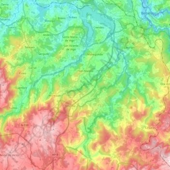
Name: Abegondo topographic map, elevation, terrain.

Location: Abegondo, A Coruña, Galicia, Spain (43.13677 -8.35920 43.29116 -8.22251)

Average elevation: 198 m

Minimum elevation: 0 m

Maximum elevation: 501 m

Other topographic maps

Click on a map to view its topography, its elevation and its terrain.

Punta Torrella

Spain > Galicia > A Coruña

Average elevation: 18 m

Monte Xalo

Spain > Galicia > A Coruña

Average elevation: 340 m

O Porto de Santa Cruz

Spain > Galicia > A Coruña

Average elevation: 40 m

Xuanzo

Spain > Galicia > A Coruña

Average elevation: 130 m

Salgueiros

Spain > Galicia > A Coruña > Quembre

Average elevation: 240 m

Oleiros

Spain > Galicia > A Coruña

Average elevation: 72 m

Gear up for your next adventure:

🛌Insulated Sleeping Pad - Critical thermal barrier between you and the cold ground
🦟Insect Repellent - Keep mosquitoes and black flies away in wooded areas
🍽️Titanium Camping Spork - Ultralight and indestructible eating utensil
💧Filtered Water Bottle - Safe drinking water on the go
💡Compact LED Flashlight - Powerful and portable flashlight for outdoor use

As an Amazon Associate, this site earns from qualifying purchases at no extra cost to you.