
Make a donation
Gear up for your next adventure:
As an Amazon Associate, this site earns from qualifying purchases at no extra cost to you.
El Puesto topographic map
Click on the map to display elevation.
Make a donation
Gear up for your next adventure:
As an Amazon Associate, this site earns from qualifying purchases at no extra cost to you.
About this map
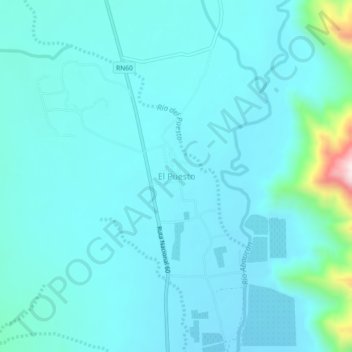
Name: El Puesto topographic map, elevation, terrain.
Average elevation: 1,356 m
Minimum elevation: 1,293 m
Maximum elevation: 1,829 m
Make a donation
Gear up for your next adventure:
As an Amazon Associate, this site earns from qualifying purchases at no extra cost to you.
Other topographic maps
Click on a map to view its topography, its elevation and its terrain.
Tinogasta
Argentina > Catamarca > Municipio de Tinogasta
La RN 60 es la principal vía actual de comunicación que posee Tinogasta, tal ruta la comunica directamente con la ciudad de Córdoba que se encuentra en el centro del sector continental americano de Argentina. La misma RN 60 dirigiéndose hacia el oeste ingresa en el transcordillerano Paso de San Francisco…
Average elevation: 1,211 m