
Make a donation
Gear up for your next adventure:
As an Amazon Associate, this site earns from qualifying purchases at no extra cost to you.
La Sage topographic map
Click on the map to display elevation.
Make a donation
Gear up for your next adventure:
As an Amazon Associate, this site earns from qualifying purchases at no extra cost to you.
About this map
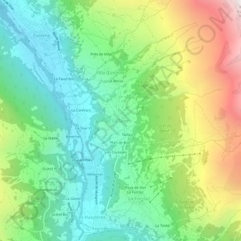
Name: La Sage topographic map, elevation, terrain.
Location: La Sage, Evolène, Hérens, Wallis, 1983, Switzerland (46.07876 7.49470 46.11876 7.53470)
Average elevation: 1,889 m
Minimum elevation: 1,326 m
Maximum elevation: 2,976 m
Make a donation
Gear up for your next adventure:
As an Amazon Associate, this site earns from qualifying purchases at no extra cost to you.
Other topographic maps
Click on a map to view its topography, its elevation and its terrain.
Evolène
Switzerland > Wallis > Hérens
At precisely 8.27 pm, the first two avalanches were set off on the slopes above Villa, at an altitude around 2,600 m (8,500 ft). They were a combination of fresh powder snow and established spring snow and demolished all trees and chalets in their path, as well as the people unlucky enough to be in the chalets…
Average elevation: 2,697 m
Make a donation
Gear up for your next adventure:
As an Amazon Associate, this site earns from qualifying purchases at no extra cost to you.