Geolocate

Hof topographic map

Click on the map to display elevation.

About this map

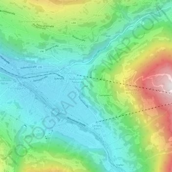
Name: Hof topographic map, elevation, terrain.

Location: Hof, Schruns, Bezirk Bludenz, Vorarlberg, 6780, Austria (47.05715 9.90646 47.09715 9.94646)

Average elevation: 964 m

Minimum elevation: 654 m

Maximum elevation: 1,705 m

Gear up for your next adventure:

💧Filtered Water Bottle - Safe drinking water on the go
Camping Groundsheet - Protect your tent from moisture and dirt
🧥Waterproof Hiking Jacket - Protect yourself from rain and wind while hiking
🥾Trail Running Boots - Durable shoes designed for trail running
🧦Thermal Socks - Warm socks for winter hiking or camping

As an Amazon Associate, this site earns from qualifying purchases at no extra cost to you.