Geolocate

Vengurla topographic map

Click on the map to display elevation.

Vengurla

Vengurla is located at 15°52′N 73°38′E / 15.87°N 73.63°E / 15.87; 73.63. It has an average elevation of 11 metres (36 ft). Vengurla is also known as Vingoria. It includes areas such as Dabholi, Khanoli, Vetore, Tendoli, Wayangani, Surangpani, Shiroda, Redi.

Wikipedia (CC-BY-SA 3.0)

About this map

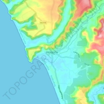
Name: Vengurla topographic map, elevation, terrain.

Location: Vengurla, Vengurla Taluka, Sindhudurg, Maharashtra, 416516, India (15.82199 73.59216 15.90199 73.67216)

Average elevation: 36 m

Minimum elevation: 0 m

Maximum elevation: 165 m

Gear up for your next adventure:

🏕️Camping Hammock - Integrated protection for sleeping between trees
🥾Waterproof Hiking Boots - Essential footwear for rugged terrain and wet Canadian trails
🩹Moleskin Blister Pads - Direct protection for painful foot pressure points
🧥Softshell Jacket - Windproof and breathable jacket for hiking
🧰Multitool Knife - Compact and versatile tool for outdoor use

As an Amazon Associate, this site earns from qualifying purchases at no extra cost to you.