Geolocate

Deharang topographic map

Click on the map to display elevation.

About this map

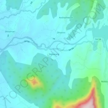
Name: Deharang topographic map, elevation, terrain.

Location: Deharang, Panvel Taluka, Raigad, Maharashtra, India (19.00472 73.20737 19.04472 73.24737)

Average elevation: 112 m

Minimum elevation: 42 m

Maximum elevation: 498 m

Other topographic maps

Click on a map to view its topography, its elevation and its terrain.

Central Park

India > Maharashtra > Panvel Taluka > Panvel

Average elevation: 25 m

Nere

India > Maharashtra > Panvel Taluka

Average elevation: 28 m

Gear up for your next adventure:

🥾Lightweight Hiking Boots - Boots for comfort and mobility on long hikes
🧥Waterproof Pants - Keep dry during rainy hiking conditions
🥘Camping Cookware Set - Compact nesting pots and pans for trail cooking
🥾Waterproof Hiking Shoes - Durable shoes for wet and rugged trails
🛶Kayak Accessories - Essential gear for safe and fun kayaking adventures

As an Amazon Associate, this site earns from qualifying purchases at no extra cost to you.