
Thank you for supporting this site ❤️
Make a donation
Make a donation
Gear up for your next adventure:
As an Amazon Associate, this site earns from qualifying purchases at no extra cost to you.
Tlachichila topographic map
Click on the map to display elevation.
Thank you for supporting this site ❤️
Make a donation
Make a donation
Gear up for your next adventure:
As an Amazon Associate, this site earns from qualifying purchases at no extra cost to you.
About this map
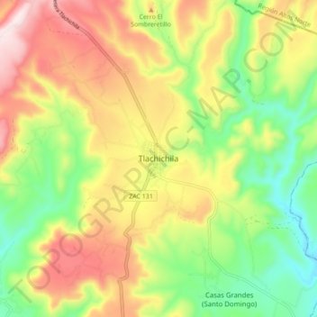
Name: Tlachichila topographic map, elevation, terrain.
Location: Tlachichila, Nochistlán de Mejía, Zacatecas, Mexico (21.51704 -102.82572 21.59704 -102.74572)
Average elevation: 2,179 m
Minimum elevation: 1,950 m
Maximum elevation: 2,452 m
Thank you for supporting this site ❤️
Make a donation
Make a donation
Gear up for your next adventure:
As an Amazon Associate, this site earns from qualifying purchases at no extra cost to you.