
Thank you for supporting this site ❤️
Make a donation
Make a donation
Gear up for your next adventure:
As an Amazon Associate, this site earns from qualifying purchases at no extra cost to you.
Fanning topographic map
Click on the map to display elevation.
Thank you for supporting this site ❤️
Make a donation
Make a donation
Gear up for your next adventure:
As an Amazon Associate, this site earns from qualifying purchases at no extra cost to you.
About this map
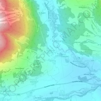
Name: Fanning topographic map, elevation, terrain.
Location: Fanning, Mariapfarr, Bezirk Tamsweg, Salisburgo, 5571, Austria (47.13422 13.69180 47.17422 13.73180)
Average elevation: 1,215 m
Minimum elevation: 1,067 m
Maximum elevation: 1,726 m
Thank you for supporting this site ❤️
Make a donation
Make a donation
Gear up for your next adventure:
As an Amazon Associate, this site earns from qualifying purchases at no extra cost to you.
Other topographic maps
Click on a map to view its topography, its elevation and its terrain.