
Thank you for supporting this site ❤️
Make a donation
Make a donation
Gear up for your next adventure:
As an Amazon Associate, this site earns from qualifying purchases at no extra cost to you.
Urireo topographic map
Click on the map to display elevation.
Thank you for supporting this site ❤️
Make a donation
Make a donation
Gear up for your next adventure:
As an Amazon Associate, this site earns from qualifying purchases at no extra cost to you.
About this map
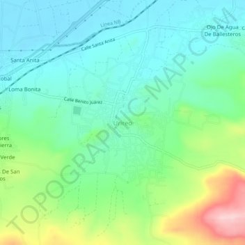
Name: Urireo topographic map, elevation, terrain.
Location: Urireo, Salvatierra, Guanajuato, 38903, Mexico (20.19322 -100.86148 20.23322 -100.82148)
Average elevation: 1,808 m
Minimum elevation: 1,745 m
Maximum elevation: 1,970 m
Thank you for supporting this site ❤️
Make a donation
Make a donation
Gear up for your next adventure:
As an Amazon Associate, this site earns from qualifying purchases at no extra cost to you.