
Härjedalens kommun topographic map
Interactive map
Click on the map to display elevation.
About this map
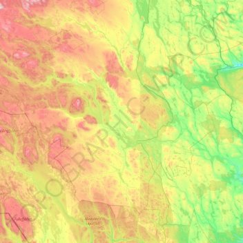
Name: Härjedalens kommun topographic map, elevation, terrain.
Location: Härjedalens kommun, Comté de Jämtland, Suède (61.56377 12.05614 62.76480 15.42921)
Average elevation: 563 m
Minimum elevation: 158 m
Maximum elevation: 1,681 m
Other topographic maps
Click on a map to view its topography, its elevation and its terrain.
Åre
Åre, Åre kommun, Comté de Jämtland, 837 52, Suède
Average elevation: 590 m
Lillhärdal
Lillhärdal, Lillhärdal distrikt, Härjedalens kommun, Comté de Jämtland, Suède
Average elevation: 459 m
Östersunds kommun
Östersunds kommun, Comté de Jämtland, Suède
Average elevation: 372 m
Sveg
Sveg, Härjedalens kommun, Comté de Jämtland, 842 32, Suède
Average elevation: 380 m
Funäsdalsberget
Suède > Comté de Jämtland > Funäsdalen
Funäsdalsberget, Funäsdalen, Härjedalens kommun, Comté de Jämtland, 840 95, Suède
Average elevation: 737 m
Önet
Suède > Comté de Jämtland > Önet
Önet, Krokoms kommun, Comté de Jämtland, Suède
Average elevation: 324 m
Canyon
Canyon, Bergs kommun, Comté de Jämtland, Suède
Average elevation: 674 m
Östersund
Östersund, Östersunds kommun, Comté de Jämtland, 831 86, Suède
Average elevation: 341 m
Undersåker
Undersåker, Åre kommun, Comté de Jämtland, 837 96, Suède
Average elevation: 418 m