
Edinburg topographic map
Interactive map
Click on the map to display elevation.
About this map
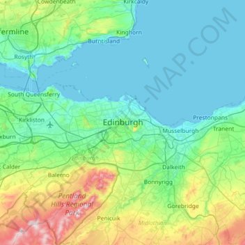
Name: Edinburg topographic map, elevation, terrain.
Average elevation: 104 m
Minimum elevation: -3 m
Maximum elevation: 578 m
Other topographic maps
Click on a map to view its topography, its elevation and its terrain.
Old Town
Vereinigtes Königreich > Schottland > Edinburg
Old Town, Edinburg, City of Edinburgh, Schottland, Vereinigtes Königreich
Average elevation: 61 m