Geolocate

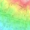
Nanggeleng topographic map

Click on the map to display elevation.

About this map

Name: Nanggeleng topographic map, elevation, terrain.

Location: Nanggeleng, Sukabumi, West Java, 43145, Indonesia (-6.95377 106.91391 -6.91377 106.95391)

Average elevation: 562 m

Minimum elevation: 471 m

Maximum elevation: 673 m

Other topographic maps

Click on a map to view its topography, its elevation and its terrain.
Gear up for your next adventure:

🥾Trail Running Boots - Durable shoes designed for trail running
🥾Waterproof Hiking Shoes - Durable shoes for wet and rugged trails
⛺Lightweight Camping Tent - Portable shelter optimized for Canadian backcountry camping
🧢Sun Protection Cap - Breathable cap to protect from sun exposure
🧢Hiking Sun Hat - Wide-brimmed protection for exposed mountain ridges

As an Amazon Associate, this site earns from qualifying purchases at no extra cost to you.