Geolocate

Gisborne topographic map

Click on the map to display elevation.

About this map

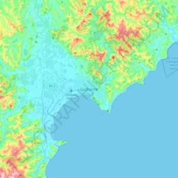
Name: Gisborne topographic map, elevation, terrain.

Location: Gisborne, Gisborne District, Gisborne, 4010, New Zealand (-38.82133 177.86065 -38.50133 178.18065)

Average elevation: 70 m

Minimum elevation: 0 m

Maximum elevation: 507 m

Gear up for your next adventure:

🔦LED Headlamp - Hands-free lighting for early morning starts or late finishes
🧥Softshell Jacket - Windproof and breathable jacket for hiking
🧥Waterproof Hiking Jacket - Protect yourself from rain and wind while hiking
🧣Merino Neck Gaiter - Protects against wind, sun, and cold at high altitudes
🧢Sun Protection Cap - Breathable cap to protect from sun exposure

As an Amazon Associate, this site earns from qualifying purchases at no extra cost to you.